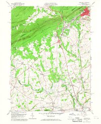
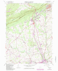
1960 Map of Wind Gap
USGS Topo · Published 1968About this map
Blue Mountain serves as a massive topographic barrier on this 1960s sheet, with the Wind Gap itself providing the primary notch for transit between the northern coal regions and the slate belt to the south. The industrial character of the region is evident in the dense concentration of quarries surrounding Pen Argyl and West Pen Argyl, where the landscape is etched by deep excavations and tailing piles. Along the base of the ridge, the Erie Lackawanna Railroad connects early industrial hamlets like Belfast Junction and Edelman. Between the ridge and the Lehigh Valley, the landscape transitions into a mix of small settlements and agriculture, marked by community centers like Bushkill Center and Moorestown. Genealogists will find numerous rural landmarks, from Benders Ch to the Evergreen Cem, which anchor the local history of these Plainfield and Bushkill township communities.
Find a feature on this map
66 named features on this map. Tap any name to fly to it.
Don’t see what you’re looking for? This feature index may not catch every label — zoom into the map to look around manually.
Map Details
Editions of this 1960 Wind Gap Map
5 editions found
Other maps of this area

1890 · Easton
USGS Topo · 1:62,500

1891 · Easton
USGS Topo · 1:62,500

1891 · Delaware Water Gap
USGS Topo · 1:62,500

1893 · Delaware Water Gap
USGS Topo · 1:62,500

1894 · Allentown
USGS Topo · 1:62,500

1914 · Wind Gap
USGS Topo · 1:62,500

1916 · Wind Gap
USGS Topo · 1:62,500

1932 · Easton
USGS Topo · 1:62,500

1936 · Delaware Water Gap
USGS Topo · 1:48,000

1939 · Allentown
USGS Topo · 1:62,500
Featured Places
- Pen Argyl, PA
- Wind Gap, PA
- Bushkill Township, PA
- Rismiller, Bushkill Township
- Wardsburg, Plainfield Township