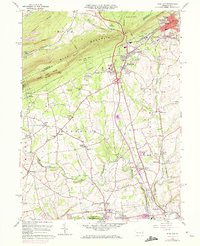
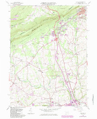
1960 Map of Wind Gap
USGS Topo · Published 1972About this map
Blue Mountain dominates the northern horizon of this landscape, where the prominent Wind Gap pass cuts through the ridge and guides the Appalachian Trail across the county line. The industrial character of the region is clearly defined by numerous quarries clustered around Pen Argyl and West Pen Argyl, illustrating the slate-producing heritage that once fueled the local economy. The network of the Lehigh and New England and Erie Lackawanna railroads connects these industrial pockets to smaller hamlets like Belfast Junction and Edelman.
Find a feature on this map
67 named features on this map. Tap any name to fly to it.
Don’t see what you’re looking for? This feature index may not catch every label — zoom into the map to look around manually.
Map Details
Editions of this 1960 Wind Gap Map
5 editions found
Other maps of this area

1890 · Easton
USGS Topo · 1:62,500

1891 · Easton
USGS Topo · 1:62,500

1891 · Delaware Water Gap
USGS Topo · 1:62,500

1893 · Delaware Water Gap
USGS Topo · 1:62,500

1894 · Allentown
USGS Topo · 1:62,500

1914 · Wind Gap
USGS Topo · 1:62,500

1916 · Wind Gap
USGS Topo · 1:62,500

1932 · Easton
USGS Topo · 1:62,500

1936 · Delaware Water Gap
USGS Topo · 1:48,000

1939 · Allentown
USGS Topo · 1:62,500
Featured Places
- Pen Argyl, PA
- Wind Gap, PA
- Bushkill Township, PA
- Rismiller, Bushkill Township
- Wardsburg, Plainfield Township