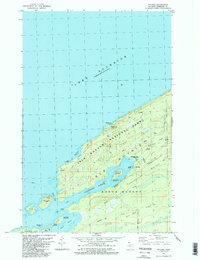
1985 Map of Windigo
USGS Topo · Published 1986About this map
Isle Royale National Park is defined by its dramatic southwestern ridges and protected harbors in this mid-1980s survey. The landscape is dominated by the parallel rises of Minong Ridge, Greenstone Ridge, and Red Oak Ridge, which dictated the routes of the Minong Trail and Greenstone Trail. Evidence of the island's industrial past remains at the Wendigo Mines near Washington Creek, while the settlement at Windigo serves as a modern focal point for park operations, featuring a Ranger Station and Washington Creek Campground. The shoreline is heavily indented, providing shelter at Washington Harbor and Grace Harbor, with numerous small islands like Johns Island and Thompson Island dotting the entrance to the North Gap. The presence of a Gaging Station and Radio Tower reflect the ongoing scientific and communications infrastructure required for this isolated location.
Find a feature on this map
40 named features on this map. Tap any name to fly to it.
Don’t see what you’re looking for? This feature index may not catch every label — zoom into the map to look around manually.
Map Details
Editions of this 1985 Windigo Map
2 editions found
Other maps of this area

1958 · Hancock
USGS Topo · 1:250,000

1959 · Fort William
USGS Topo · 1:250,000

1960 · Hancock
USGS Topo · 1:250,000

1961 · Hancock
USGS Topo · 1:250,000

1966 · Hancock
USGS Topo · 1:250,000

1968 · Fort William
USGS Topo · 1:250,000

1985 · Pigeon Point
USGS Topo · 1:100,000

1985 · Grand Portage
USGS Topo · 1:100,000
1985 · Feldtmann Ridge
USGS Topo · 1:24,000
1985 · Feldtmann Lake
USGS Topo · 1:24,000