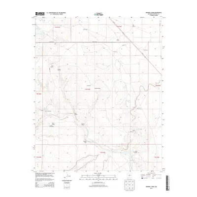
2013 Map of Windmill Draw
USGS Topo · Published 2013About this map
York Ranch and Walton Ranch anchor this arid landscape in De Baca County, where the cattle-ranching economy is mapped through an extensive network of watering points. The terrain is defined by the sharp descent of Pacheco Bluff and the winding course of the Pecos River, which flows south from the reservoir at Lake Sumner. The importance of water management in this high-desert environment is evident in the naming of nearly a dozen distinct windmills, from the North Windmill to the Winter Horse Pasture Windmill, alongside natural features like Carretas Springs and James Spring. This 2013 survey provides a detailed look at the rural road network, including the path of Us-84 and local tracks like Carretas Rd, which facilitate movement between these isolated ranching outposts and the natural landmarks of Windmill Draw and Dark Canyon.
Find a feature on this map
38 named features on this map. Tap any name to fly to it.
Don’t see what you’re looking for? This feature index may not catch every label — zoom into the map to look around manually.
Map Details
Editions of this 2013 Windmill Draw Map
This is the sole edition of this map. No revisions or reprints were ever made.
Other maps of this area

1954 · Fort Sumner
USGS Topo · 1:250,000

1958 · Fort Sumner
USGS Topo · 1:250,000

1965 · Fort Sumner West
USGS Topo · 1:24,000

1965 · Windmill Draw
USGS Topo · 1:24,000

1966 · Gibbons Ranch
USGS Topo · 1:24,000

1966 · Ricardo
USGS Topo · 1:24,000

1966 · Alamogordo Dam
USGS Topo · 1:24,000

1966 · Colorado Canyon
USGS Topo · 1:24,000

1968 · Twin Mesa NW
USGS Topo · 1:24,000

1968 · Fort Sumner East
USGS Topo · 1:24,000