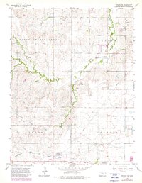
1965 Map of Windom NE
USGS Topo · Published 1980About this map
Sharps Creek and its tributaries, including North Branch Sharps Creek and South Sharps Creek, carve through the rolling sections of western McPherson County. This 1965 survey, updated with 1978 aerial data, highlights a rural landscape shaped by both early pioneers and modern energy infrastructure. Genealogists can locate several local burial grounds, such as Windom Cem, Fairview Cem, and Excelsior Cem, which remain as markers of the township settlements in South Sharps Creek, Harper, Castle, and Jackson.
Find a feature on this map
19 named features on this map. Tap any name to fly to it.
Don’t see what you’re looking for? This feature index may not catch every label — zoom into the map to look around manually.
Map Details
Editions of this 1965 Windom NE Map
3 editions found
Other maps of this area

1891 · Hutchinson
USGS Topo · 1:125,000

1892 · Salina
USGS Topo · 1:125,000

1893 · Hutchinson
USGS Topo · 1:125,000

1942 · Salina
USGS Topo · 1:125,000

1955 · Hutchinson
USGS Topo · 1:250,000

1959 · Hutchinson
USGS Topo · 1:250,000

1964 · Marquette
USGS Topo · 1:24,000
1964 · Langley
USGS Topo · 1:24,000

1964 · Windom SW
USGS Topo · 1:24,000

1964 · Conway
USGS Topo · 1:24,000