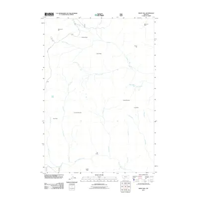
2011 Map of Windy Hill
USGS Topo · Published 2011About this map
Windy Hill and the surrounding high-country terrain dominate this 2011 survey, revealing a landscape defined by sharp divides and alpine water bodies. The northeastern corner is home to the Elk River and its headwater tributaries like Nelson Creek, while the southern reaches are marked by the West Fork Madison River. High-altitude features such as Blue Lake and Fault Lake sit tucked between prominent peaks, including Cascade Mountain and Fossil Peak. The presence of the Gravelly Range Rd provides the primary access through this complex drainage network, which separates the Elk River Basin from the expansive Lobo Mesa. This map is particularly useful for understanding the hydrography of the region, tracing the paths of Hellroaring Creek and Cascade Creek as they descend from Crater Ridge and Divide Mountain.
Find a feature on this map
26 named features on this map. Tap any name to fly to it.
Don’t see what you’re looking for? This feature index may not catch every label — zoom into the map to look around manually.
Map Details
Editions of this 2011 Windy Hill Map
This is the sole edition of this map. No revisions or reprints were ever made.
Other maps of this area

1950 · Cliff Lake
USGS Topo · 1:62,500

1950 · Lower Red Rock Lake
USGS Topo · 1:62,500

1950 · Monument Ridge
USGS Topo · 1:62,500

1950 · Upper Red Rock Lake
USGS Topo · 1:62,500

1955 · Ashton
USGS Topo · 1:250,000

1958 · Ashton
USGS Topo · 1:250,000

1960 · Ashton
USGS Topo · 1:250,000
1988 · Granite Mountain
USGS Topo · 1:24,000
1988 · Bighorn Mountain
USGS Topo · 1:24,000
1988 · Eureka Basin
USGS Topo · 1:24,000