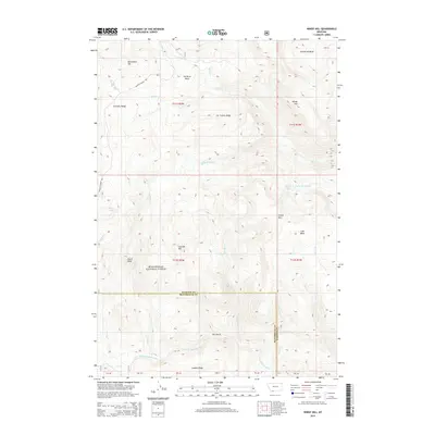
2014 Map of Windy Hill
USGS Topo · Published 2014About this map
Beaverhead National Forest land dominates this high-altitude terrain, where the boundary between Madison and Beaverhead counties follows the natural drainage divides. The landscape is defined by massive ridges and peaks, from Monument Hill in the northwest to the eponymous Windy Hill and Divide Mtn further south. Waterways carve deep basins into the range, including the Elk River and the headwaters of the W Fork Madison River which flows across the southern flats. The Gravelly Range Rd provides the primary transit route through this complex topography, passing near landmarks like Crater Ridge and Wolverine Basin. For those interested in mountain geography, the map reveals a network of named peaks and canyons, including Cascade Mtn and Dry Gulch, showing how early surveyors identified this remote section of the Montana Rockies.
Find a feature on this map
34 named features on this map. Tap any name to fly to it.
Don’t see what you’re looking for? This feature index may not catch every label — zoom into the map to look around manually.
Map Details
Editions of this 2014 Windy Hill Map
This is the sole edition of this map. No revisions or reprints were ever made.
Other maps of this area

1950 · Cliff Lake
USGS Topo · 1:62,500

1950 · Lower Red Rock Lake
USGS Topo · 1:62,500

1950 · Monument Ridge
USGS Topo · 1:62,500

1950 · Upper Red Rock Lake
USGS Topo · 1:62,500

1955 · Ashton
USGS Topo · 1:250,000

1958 · Ashton
USGS Topo · 1:250,000

1960 · Ashton
USGS Topo · 1:250,000
1988 · Granite Mountain
USGS Topo · 1:24,000
1988 · Bighorn Mountain
USGS Topo · 1:24,000
1988 · Eureka Basin
USGS Topo · 1:24,000