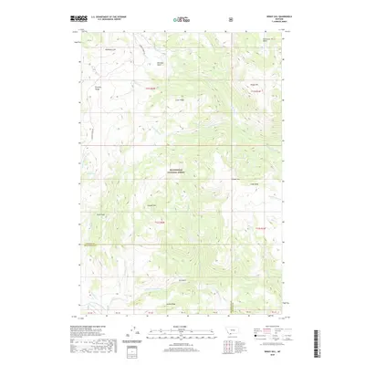
2020 Map of Windy Hill
USGS Topo · Published 2020About this map
The Beaverhead National Forest defines the high-altitude landscape shown here, where the Gravelly Range dominates the western topography. This area is characterized by a complex drainage network where the W Fork Madison River and numerous tributaries like Hellroaring Cr and Fossil Cr carve through prominent ridges. Geological and topographical diversity is evident in features such as Crater Ridge and the broad Lobo Mesa, which sits between Divide Mtn and the Tepee Cr drainage.
Find a feature on this map
35 named features on this map. Tap any name to fly to it.
Don’t see what you’re looking for? This feature index may not catch every label — zoom into the map to look around manually.
Map Details
Editions of this 2020 Windy Hill Map
This is the sole edition of this map. No revisions or reprints were ever made.
Other maps of this area

1950 · Cliff Lake
USGS Topo · 1:62,500

1950 · Lower Red Rock Lake
USGS Topo · 1:62,500

1950 · Monument Ridge
USGS Topo · 1:62,500

1950 · Upper Red Rock Lake
USGS Topo · 1:62,500

1955 · Ashton
USGS Topo · 1:250,000

1958 · Ashton
USGS Topo · 1:250,000

1960 · Ashton
USGS Topo · 1:250,000
1988 · Granite Mountain
USGS Topo · 1:24,000
1988 · Bighorn Mountain
USGS Topo · 1:24,000
1988 · Eureka Basin
USGS Topo · 1:24,000