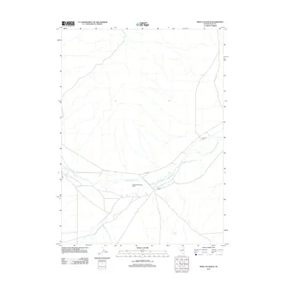
2012 Map of Wine Cup Ranch
USGS Topo · Published 2012About this map
Thousand Springs Valley defines this high-desert landscape of northeastern Elko County, where water sources dictate the placement of local infrastructure and ranching operations. The area is anchored by the eponymous Wine Cup Ranch, a significant landmark in this arid basin. Essential water features like Wine Cup Spring, Indian Spring, and the winding Thousand Springs Creek provide the lifeblood for the region's livestock economy. The transportation network is sparse, centered on Co Hwy-785 and Winecup Ranch Rd, which connect the primary ranching headquarters with outlying points like Threemile Ranch. This 2012 survey captures the persistent rural character of the Nevada interior, where the drainage of Brush Creek and various spring-fed runs represent the primary geographical focus in an otherwise open expanse.
Find a feature on this map
9 named features on this map. Tap any name to fly to it.
Don’t see what you’re looking for? This feature index may not catch every label — zoom into the map to look around manually.
Map Details
Editions of this 2012 Wine Cup Ranch Map
This is the sole edition of this map. No revisions or reprints were ever made.
Other maps of this area

1955 · Wells
USGS Topo · 1:250,000

1958 · Wells
USGS Topo · 1:250,000

1961 · Wells
USGS Topo · 1:250,000

1968 · Wilkins
USGS Topo · 1:24,000

1968 · Melandco
USGS Topo · 1:24,000

1968 · Knoll Mountain
USGS Topo · 1:24,000

1968 · Knoll Mountain SE
USGS Topo · 1:24,000

1968 · Wine Cup Ranch SE
USGS Topo · 1:24,000

1968 · Wine Cup Ranch
USGS Topo · 1:24,000
1968 · Wine Cup Ranch SW
USGS Topo · 1:24,000