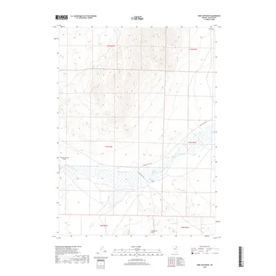
2018 Map of Wine Cup Ranch
USGS Topo · Published 2018About this map
Wine Cup Ranch sits at the heart of this high-desert landscape in northeastern Nevada, where the hydrology of the Thousand Springs Valley dictates the settlement pattern. The terrain is defined by the significant wetlands and ephemeral flows of Thousand Springs Cr, which transitions from a defined stream to broad marshy basins. This 2018 survey illustrates how ranching operations rely on scattered water sources like Wine Cup Ranch Spring and Indian Spring to manage livestock across the varied topography. To the north, the H D Range rises sharply, while the southern portion of the quadrangle is occupied by the Windermere Hills. Transport through this remote corner of Elko County is restricted to the Wilkins-Montello Rd and Winecup Ranch Rd, which connect the ranching headquarters to the broader region across the sagebrush-covered flats and broken hills.
Find a feature on this map
16 named features on this map. Tap any name to fly to it.
Don’t see what you’re looking for? This feature index may not catch every label — zoom into the map to look around manually.
Map Details
Editions of this 2018 Wine Cup Ranch Map
This is the sole edition of this map. No revisions or reprints were ever made.
Other maps of this area

1955 · Wells
USGS Topo · 1:250,000

1958 · Wells
USGS Topo · 1:250,000

1961 · Wells
USGS Topo · 1:250,000

1968 · Wilkins
USGS Topo · 1:24,000

1968 · Melandco
USGS Topo · 1:24,000

1968 · Knoll Mountain
USGS Topo · 1:24,000

1968 · Knoll Mountain SE
USGS Topo · 1:24,000

1968 · Wine Cup Ranch SE
USGS Topo · 1:24,000

1968 · Wine Cup Ranch
USGS Topo · 1:24,000
1968 · Wine Cup Ranch SW
USGS Topo · 1:24,000