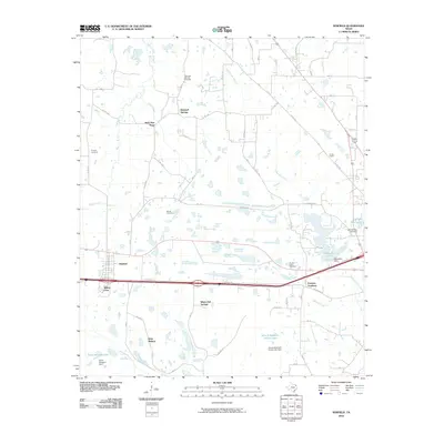
2010 Map of Winfield
USGS Topo · Published 2010About this map
Winfield serves as the central hub of this East Texas landscape, positioned along the primary transit corridor that separates the northern creek basins from the southern ranch and timber lands. The map reveals a high density of rural communities and crossroads, such as Farmers Academy, Marshall Springs, and West New Hope, reflecting a long-standing pattern of dispersed agricultural settlement. Water management is a defining characteristic of the terrain, with numerous impoundments like Tankersley Lake, John W May Lake, and John B Stephens Junior Lake punctuating the courses of Ripley Creek and Dragoo Creek. For genealogists, the distribution of local burial grounds, including Tranquil Cemetery and Barrett Cemetery, provides a clear spatial record of the area's established families and historic congregations.
Find a feature on this map
42 named features on this map. Tap any name to fly to it.
Don’t see what you’re looking for? This feature index may not catch every label — zoom into the map to look around manually.
Map Details
Editions of this 2010 Winfield Map
This is the sole edition of this map. No revisions or reprints were ever made.
Other maps of this area

1953 · Texarkana
USGS Topo · 1:250,000

1956 · Texarkana
USGS Topo · 1:250,000

1964 · Mount Vernon
USGS Topo · 1:24,000

1964 · Harvard
USGS Topo · 1:24,000

1964 · Wilkinson
USGS Topo · 1:24,000

1964 · Talco
USGS Topo · 1:24,000

1964 · Hagansport
USGS Topo · 1:24,000

1965 · Winfield
USGS Topo · 1:24,000

1965 · Monticello
USGS Topo · 1:24,000
1965 · New Hope
USGS Topo · 1:24,000