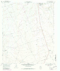
1968 Map of Wink South
USGS Topo · Published 1981About this map
The West Texas town of Wink serves as the hub of this 1968 landscape, which sits at the intersection of the Winkler County and Ward County line. The area is defined by the heavy infrastructure of the regional energy industry, marked by numerous Oil Wells, a Pumping Sta, and a Gas Well. These industrial features are interspersed with ranching landmarks such as Harvel Windmill, China Windmill, and Oats Windmill, illustrating the dual-use nature of the Permian Basin during this era.
Find a feature on this map
28 named features on this map. Tap any name to fly to it.
Don’t see what you’re looking for? This feature index may not catch every label — zoom into the map to look around manually.
Map Details
Editions of this 1968 Wink South Map
2 editions found
Other maps of this area

1954 · Pecos
USGS Topo · 1:250,000

1957 · Pecos
USGS Topo · 1:250,000

1968 · Soda Lake SE
USGS Topo · 1:24,000

1968 · Wink South
USGS Topo · 1:24,000

1968 · Soda Lake NE
USGS Topo · 1:24,000

1969 · Pyote NE
USGS Topo · 1:24,000

1969 · Pyote East
USGS Topo · 1:24,000
1969 · Pyote West
USGS Topo · 1:24,000

1970 · Wink North
USGS Topo · 1:24,000

1970 · Cheyenne Draw SE
USGS Topo · 1:24,000