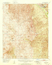
1951 Map of Winkelman
USGS Topo · Published 1951About this map
The junction of the Gila River and San Pedro River anchors this mid-century portrait of southern Arizona's ranching and mining heartland. The community of Winkelman sits near the northern boundary, where the industrial presence of a large Tailings Pond and the Southern Pacific railroad reflect the region's heavy mineral extraction. To the south, the rugged terrain of the Tortilla Mountains is dotted with numerous family ranch sites, some already noted as historical locations by the late 1940s.
Find a feature on this map
59 named features on this map. Tap any name to fly to it.
Don’t see what you’re looking for? This feature index may not catch every label — zoom into the map to look around manually.
Map Details
Editions of this 1951 Winkelman Map
2 editions found
Other maps of this area

1900 · Florence
USGS Topo · 1:125,000

1902 · Florence
USGS Topo · 1:125,000

1910 · Ray
USGS Topo · 1:62,500

1911 · Winkelman
USGS Topo · 1:125,000

1913 · Winkelman
USGS Topo · 1:125,000

1915 · Christmas
USGS Topo · 1:62,500

1917 · Christmas
USGS Topo · 1:62,500

1934 · Newman Peak
USGS Topo · 1:125,000

1948 · Mammoth
USGS Topo · 1:62,500

1948 · Mammoth
USGS Topo · 1:24,000