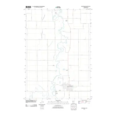
2010 Map of Winnebago
USGS Topo · Published 2010About this map
The Blue Earth River meanders through the heart of this Faribault County landscape, defining the character of the city of Winnebago. This 2010 topographic record shows a meticulously gridded agricultural region structured by numerous drainage systems, including County Ditch Number Twentythree and Judicial Ditch Number Twentyfive, which support the intensive farming around the river valley. The map is particularly valuable for genealogical research, documenting several distinct burial grounds such as the Pioneer Shelbyville Cemetery and Saint Marys Cemetery. Within the city limits, the Winnebago Post Office serves as a central landmark amidst a traditional residential and commercial street plan. To the south, Elm Creek feeds into the river system, further illustrating the complex hydrology of this southern Minnesota prairie region.
Find a feature on this map
52 named features on this map. Tap any name to fly to it.
Don’t see what you’re looking for? This feature index may not catch every label — zoom into the map to look around manually.
Map Details
Editions of this 2010 Winnebago Map
This is the sole edition of this map. No revisions or reprints were ever made.
Other maps of this area

1954 · Fairmont
USGS Topo · 1:250,000

1958 · Fairmont
USGS Topo · 1:250,000

1967 · Truman SE
USGS Topo · 1:24,000

1967 · Winnebago
USGS Topo · 1:24,000

1967 · Willow Creek
USGS Topo · 1:24,000

1967 · Granada
USGS Topo · 1:24,000

1967 · Huntley
USGS Topo · 1:24,000
1967 · Amboy
USGS Topo · 1:24,000
1967 · Delavan
USGS Topo · 1:24,000
1967 · Sterling Center
USGS Topo · 1:24,000