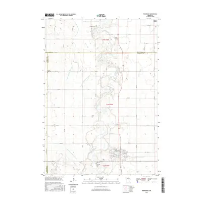
2016 Map of Winnebago
USGS Topo · Published 2016About this map
Winnebago anchors this landscape of the Faribault County prairie, where the Blue Earth River and its tributaries define the local geography. The area's pioneer heritage is exceptionally well-documented through numerous burial grounds, including the Pioneer Shelbyville Cem and Pleasant View Cem in the north, and a cluster near the town center featuring Riverside Cem, Saint Marys Cem, and Hill Cem. The drainage patterns of the region are heavily modified by a network of public infrastructure, such as County Ditch Number Twentyfour and Judicial Ditch Number Twentyfive, which converted former wetlands like the Jackson Lakebed into productive land. This survey captures the intersection of natural watercourses like Elm Cr with the rigid section-line road grid that has structured Minnesota's agricultural heartland since the nineteenth century.
Find a feature on this map
79 named features on this map. Tap any name to fly to it.
Don’t see what you’re looking for? This feature index may not catch every label — zoom into the map to look around manually.
Map Details
Editions of this 2016 Winnebago Map
This is the sole edition of this map. No revisions or reprints were ever made.
Other maps of this area

1954 · Fairmont
USGS Topo · 1:250,000

1958 · Fairmont
USGS Topo · 1:250,000

1967 · Truman SE
USGS Topo · 1:24,000

1967 · Winnebago
USGS Topo · 1:24,000

1967 · Willow Creek
USGS Topo · 1:24,000

1967 · Granada
USGS Topo · 1:24,000

1967 · Huntley
USGS Topo · 1:24,000
1967 · Amboy
USGS Topo · 1:24,000
1967 · Delavan
USGS Topo · 1:24,000
1967 · Sterling Center
USGS Topo · 1:24,000