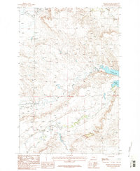
1986 Map of Winnett South
USGS Topo · Published 1986About this map
Flatwillow Creek and Alkali Creek dominate the southern landscape of this Central Montana survey, where water dictates the patterns of ranching and land use in Petroleum County. The map documents a critical hydrologic network as it stood in the mid-1980s, anchored by Petrolia Lake in the northeast. This area, located south of the town of Winnett, shows a rugged topography marked by the confluence of Yellow Water Creek and Mc Donald Creek. These drainages have historically defined the boundaries of grazing lands and travel corridors in this high plains region. The presence of numerous wells throughout the quadrangle reflects the importance of sub-surface resources and stock water in an arid environment. Researchers of Montana’s agricultural and petroleum history can trace the detailed township lines, such as the division between T 14 N and T 13 N, which continue to define property and mineral rights today.
Find a feature on this map
7 named features on this map. Tap any name to fly to it.
Don’t see what you’re looking for? This feature index may not catch every label — zoom into the map to look around manually.
Map Details
Editions of this 1986 Winnett South Map
2 editions found
Other maps of this area

1954 · Roundup
USGS Topo · 1:250,000

1954 · Lewistown
USGS Topo · 1:250,000

1958 · Roundup
USGS Topo · 1:250,000

1959 · Lewistown
USGS Topo · 1:250,000

1963 · Kelley
USGS Topo · 1:24,000

1963 · Petrolia Lake
USGS Topo · 1:24,000

1986 · Ingals Dam
USGS Topo · 1:24,000

1986 · Flatwillow
USGS Topo · 1:24,000

1986 · Winnett North
USGS Topo · 1:24,000

1986 · Crowley Dam
USGS Topo · 1:24,000