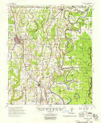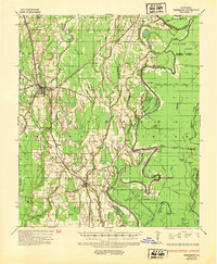
1935 Map of Winnsboro
USGS Topo · Published 1954About this map
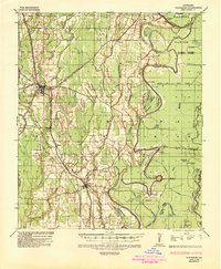
Winnsboro serves as the focal point of this mid-1930s landscape, where the agricultural and timber economies of Franklin Parish are deeply tied to the winding course of the Macon River. The survey captures a network of river crossings essential for local travel before modern bridges were universal, including Montgomery Ferry, Egypt Ferry, and Osbornes Ferry. Industrial activity is marked by the Chicago Mill & Lumber Company near the riverbanks, while the path of the Interstate Natural Gas Pipe Line and several high-voltage lines from Pacific Power and Light Co indicate the early modernization of rural infrastructure. Smaller communities like Gilbert, Chase, and Crowville are connected by the nascent highway system, with State Highway No 48 shown under construction, illustrating a period of significant transit development across the Louisiana lowlands.
Find a feature on this map
57 named features on this map. Tap any name to fly to it.
Don’t see what you’re looking for? This feature index may not catch every label — zoom into the map to look around manually.
Map Details
Editions of this 1935 Winnsboro Map
2 editions found
Historical Maps of Winnsboro Through Time
8 maps found