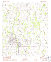
1983 Map of Winnsboro
USGS Topo · Published 1984About this map
Winnsboro serves as the focal point of this 1980s landscape, positioned between the Missouri Pacific railroad line and the winding course of Turkey Creek. The town's layout reflects a hub of civic and educational life, featuring the Voc-Tech Sch, High Sch, and essential local sites like City Hall and the Library. Genealogists will find a high density of burial grounds in the vicinity, including the Old Winnsboro Cem, Myrtle Mem Cem, and Pine Grove Cem.
Find a feature on this map
43 named features on this map. Tap any name to fly to it.
Don’t see what you’re looking for? This feature index may not catch every label — zoom into the map to look around manually.
Map Details
Editions of this 1983 Winnsboro Map
This is the sole edition of this map. No revisions or reprints were ever made.
Other maps of this area

1935 · Winnsboro
USGS Topo · 1:62,500

1935 · Alto
USGS Topo · 1:62,500

1935 · Baskinton
USGS Topo · 1:62,500

1939 · Fort Necessity
USGS Topo · 1:62,500

1955 · Jackson
USGS Topo · 1:250,000

1957 · Mangham
USGS Topo · 1:62,500

1958 · Baskinton
USGS Topo · 1:62,500

1958 · Winnsboro
USGS Topo · 1:62,500

1958 · Fort Necessity
USGS Topo · 1:62,500

1961 · Jackson
USGS Topo · 1:250,000