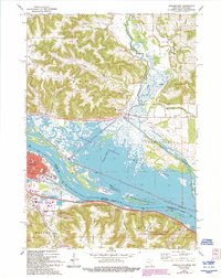
1972 Map of Winona East
USGS Topo · Published 1993About this map
Winona sits at the heart of a complex riverine environment where the Mississippi River and Trempealeau River converge. This 1972 survey, updated in the early 1990s, documents the industrial and educational infrastructure of the city, including the Winona Area Technical School and landmarks like St Stanislaus Ch. The landscape is defined by the dramatic relief of Buffalo Ridge and several prominent valleys like Platt Valley and Dodge Valley, which channel toward the vast wetlands. Across the river in Wisconsin, the rail infrastructure is prominent at Bluff Siding and Marshland. The map also captures significant conservation areas, including the Trempealeau National Wildlife Refuge and the Richard J Dorer Memorial Hardwood State Forest, illustrating the balance between urban development and the protected backwaters of the Upper Mississippi.
Find a feature on this map
46 named features on this map. Tap any name to fly to it.
Don’t see what you’re looking for? This feature index may not catch every label — zoom into the map to look around manually.
Map Details
Editions of this 1972 Winona East Map
3 editions found
Other maps of this area

1929 · Fountain City
USGS Topo · 1:62,500

1929 · Galesville
USGS Topo · 1:62,500

1930 · La Crescent
USGS Topo · 1:62,500

1934 · Winona
USGS Topo · 1:62,500

1937 · Winona
USGS Topo · 1:62,500

1953 · Eau Claire
USGS Topo · 1:250,000

1956 · La Crescent
USGS Topo · 1:62,500

1958 · Eau Claire
USGS Topo · 1:250,000

1958 · Houston
USGS Topo · 1:62,500

1958 · La Crosse
USGS Topo · 1:250,000