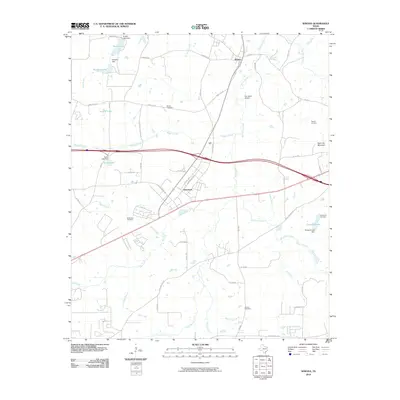
2010 Map of Winona
USGS Topo · Published 2010About this map
Winona and the industrial corridors near Owentown define this corner of Smith County at the turn of the decade. The landscape is a network of managed water and legacy landmarks, from the complex of reservoirs like Timber Lake and Pinedale Lake in the north to Pineland Lake in the southeast. Significant local history is preserved in numerous burial grounds scattered throughout the quadrangle, including the Antioch Cemetery near Antioch Branch and the McDougle Cemetery south of Wiggins Creek. The terrain is punctuated by the rise of Starrville Mountain and served by small-scale aviation at the Kay Ranch Airport. Extensive drainage systems like Harris Creek and Ray Creek carve through the region, illustrating the hydrological patterns that have historically influenced settlement and road placement in this part of East Texas.
Find a feature on this map
62 named features on this map. Tap any name to fly to it.
Don’t see what you’re looking for? This feature index may not catch every label — zoom into the map to look around manually.
Map Details
Editions of this 2010 Winona Map
This is the sole edition of this map. No revisions or reprints were ever made.
Other maps of this area

1938 · Winona
USGS Topo · 1:48,000

1943 · Winona
USGS Topo · 1:62,500

1948 · Tyler
USGS Topo · 1:62,500

1949 · Tyler
USGS Topo · 1:62,500

1956 · Tyler
USGS Topo · 1:250,000

1960 · Hawkins
USGS Topo · 1:24,000

1960 · Big Sandy
USGS Topo · 1:24,000

1960 · Crow
USGS Topo · 1:24,000

1966 · Hope Pond
USGS Topo · 1:24,000
1966 · Starrville
USGS Topo · 1:24,000