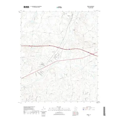
2019 Map of Winona
USGS Topo · Published 2019About this map
Winona and Owentown anchor this portion of northeast Smith County, sitting amidst a landscape deeply etched by the drainage basins of Wiggins Cr and Harris Cr. The terrain reveals a transition from the lower creek bottoms to localized high points like Starville Mtn, where the Ingram Cem is located. The area north of Tyler shows a dense network of country roads and local arteries like FM 2015, which pass through a territory punctuated by numerous family and community burial grounds, including Marsh Cem, McDougal Cem, and Antioch Cem. Significant water features such as Pinedale Lake and Driscoll Lake provide clear evidence of the region's managed hydrology. The inclusion of Kay Ranch Airport and the expanding road infrastructure near Owentown reflects the ongoing development of this corridor as it connects smaller rural outposts to the regional hub of Tyler.
Find a feature on this map
96 named features on this map. Tap any name to fly to it.
Don’t see what you’re looking for? This feature index may not catch every label — zoom into the map to look around manually.
Map Details
Editions of this 2019 Winona Map
This is the sole edition of this map. No revisions or reprints were ever made.
Other maps of this area

1938 · Winona
USGS Topo · 1:48,000

1943 · Winona
USGS Topo · 1:62,500

1948 · Tyler
USGS Topo · 1:62,500

1949 · Tyler
USGS Topo · 1:62,500

1956 · Tyler
USGS Topo · 1:250,000

1960 · Hawkins
USGS Topo · 1:24,000

1960 · Big Sandy
USGS Topo · 1:24,000

1960 · Crow
USGS Topo · 1:24,000

1966 · Hope Pond
USGS Topo · 1:24,000
1966 · Starrville
USGS Topo · 1:24,000