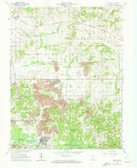
1961 Map of Winslow
USGS Topo · Published 1973About this map
The Patoka River meanders across the southern landscape of this Pike County region, where the town of Winslow serves as a central hub near the Southern railroad line. This era is defined by a significant transition in land use, as traditional farming and forestry in the Pike County State Forest sit adjacent to large-scale Strip Mine operations. These mining scars dominate the central and western portions of the terrain, often reshaping the local topography near Campbelltown. For the family historian, the map preserves the locations of numerous community anchors, including the Flat Creek Memorial Ch and several family-named burial grounds like McClure Cem and Beadles Cem. The network of small settlements like Algiers and Whiteoak are connected by a web of rural routes such as Sugar Ridge Road and Bruster Road.
Find a feature on this map
40 named features on this map. Tap any name to fly to it.
Don’t see what you’re looking for? This feature index may not catch every label — zoom into the map to look around manually.
Map Details
Editions of this 1961 Winslow Map
Other maps of this area

1902 · Ditney
USGS Topo · 1:125,000

1903 · Velpen
USGS Topo · 1:62,500

1903 · Petersburg
USGS Topo · 1:62,500

1944 · Glendale
USGS Topo · 1:24,000

1944 · Monroe City
USGS Topo · 1:24,000

1945 · Sandy Hook
USGS Topo · 1:24,000

1956 · Vincennes
USGS Topo · 1:250,000

1957 · Vincennes
USGS Topo · 1:250,000

1958 · Vincennes
USGS Topo · 1:250,000
1958 · Monroe City
USGS Topo · 1:24,000