
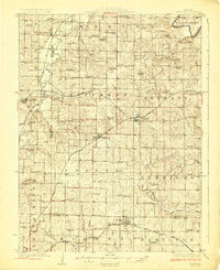
1924 Map of Winston
USGS Topo · Published 1924About this map
Chicago Rock Island and Pacific rails intersect at Winston, forming a central hub for this portion of Daviess and Caldwell counties in the early 1920s. The landscape is characterized by a dense network of rural infrastructure, where nearly every section of land is served by a local namesake school or church. The Grand River cuts through the northeast corner, while smaller drainages like Muddy Creek and Rock Island Creek define the agricultural terrain.
Find a feature on this map
83 named features on this map. Tap any name to fly to it.
Don’t see what you’re looking for? This feature index may not catch every label — zoom into the map to look around manually.
Map Details
Editions of this 1924 Winston Map
3 editions found
Other maps of this area

1922 · Gallatin
USGS Topo · 1:62,500

1923 · Maysville
USGS Topo · 1:62,500

1924 · Polo
USGS Topo · 1:62,500

1924 · Braymer
USGS Topo · 1:62,500

1925 · Pattonsburg
USGS Topo · 1:62,500

1925 · Plattsburg
USGS Topo · 1:62,500

1925 · Gilman
USGS Topo · 1:62,500

1925 · Maysville
USGS Topo · 1:62,500

1925 · Darlington
USGS Topo · 1:62,500

1944 · Pattonsburg
USGS Topo · 1:62,500