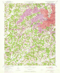
1950 Map of Winston-Salem West
USGS Topo · Published 1973About this map
Winston-Salem Winston Twp shows a period of significant mid-century transition as urban boundaries moved westward into the surrounding South Fork countryside. Residential developments like Buena Vista and Ardmore appear as dense grids, while the purple overprint indicates the rapid expansion of suburban culture by the early 1970s. The landscape is dotted with long-standing community pillars, including numerous local congregations such as Mt Tabor Ch and New Philadelphia Ch, reflecting the area's deep-rooted social fabric.
Find a feature on this map
61 named features on this map. Tap any name to fly to it.
Don’t see what you’re looking for? This feature index may not catch every label — zoom into the map to look around manually.
Map Details
Editions of this 1950 Winston-Salem West Map
4 editions found
Other maps of this area

1949 · Eller
USGS Topo · 1:24,000

1950 · Winston-Salem West
USGS Topo · 1:24,000

1950 · Winston-Salem East
USGS Topo · 1:24,000

1951 · Winston-Salem West
USGS Topo · 1:24,000

1951 · Winston-Salem East
USGS Topo · 1:24,000

1951 · Rural Hall
USGS Topo · 1:24,000

1951 · Walkertown
USGS Topo · 1:24,000

1953 · Charlotte
USGS Topo · 1:250,000

1953 · Winston-Salem
USGS Topo · 1:250,000

1954 · Charlotte
USGS Topo · 1:250,000
Featured Places
- Winston-Salem, NC
- Clemmons, NC
- South Fork, Winston-Salem
- Echo Bluff Trailer Park, NC
- West Highlands, Winston-Salem