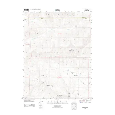
2013 Map of Winter Flats
USGS Topo · Published 2013About this map
Winter Flats and the prominent South Shale Ridge characterize this high-elevation terrain along the border of Garfield and Mesa counties. The landscape is defined by a dense network of erosional features, including Horseshoe Canyon and the winding Little Alkali Canyon that drain the mesas. In the northern reaches, Willow Spring provides a rare water source among the gulches, while the southern section is dominated by significant landforms like Redrock Point and Jackson Canyon. This 2013 survey illustrates the modern system of rural county roads, such as V 2/10 Rd and 35 10 Rd, which provide access through the complex topography of Main Canyon and Cosgrove Canyon. The map offers a precise view of the local drainage patterns and natural landmarks that have guided movement through this part of the Colorado Plateau for generations.
Find a feature on this map
34 named features on this map. Tap any name to fly to it.
Don’t see what you’re looking for? This feature index may not catch every label — zoom into the map to look around manually.
Map Details
Editions of this 2013 Winter Flats Map
This is the sole edition of this map. No revisions or reprints were ever made.
Other maps of this area

1929 · Roan Creek
USGS Topo · 1:62,500

1955 · Cameo
USGS Topo · 1:24,000

1956 · Grand Junction
USGS Topo · 1:250,000

1959 · Grand Junction
USGS Topo · 1:250,000

1960 · Grand Junction
USGS Topo · 1:250,000

1962 · Grand Junction
USGS Topo · 1:250,000
1962 · Round Mountain
USGS Topo · 1:24,000

1962 · Corcoran Point
USGS Topo · 1:24,000

1964 · Grand Junction
USGS Topo · 1:250,000

1965 · Grand Junction
USGS Topo · 1:250,000