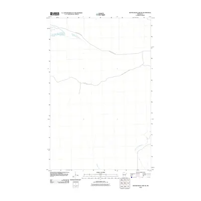
2010 Map of Winter Road Lake SE
USGS Topo · Published 2010About this map
Browns Lake sits in the northwest corner of this northern Minnesota landscape, a quiet water body in the heavily forested reaches of Lake of the Woods County. The terrain is defined by a network of drainage and isolated wetlands, where Meadow Creek flows southward and the North Branch Rapid River cuts across the southeast. In this era, the area remained largely undeveloped, accessible primarily via long-reaching forest roads such as the Faunce-Butterfield Rd and the Hogsback Obrien-Forest Rd. These routes provide the few markers of human movement through a remote wilderness, which is characterized by subtle elevation changes and an intricate hydrographic system at the start of the 21st century.
Find a feature on this map
5 named features on this map. Tap any name to fly to it.
Don’t see what you’re looking for? This feature index may not catch every label — zoom into the map to look around manually.
Map Details
Editions of this 2010 Winter Road Lake SE Map
This is the sole edition of this map. No revisions or reprints were ever made.
Other maps of this area

1918 · Winterroad
USGS Topo · 1:62,500

1918 · F
USGS Topo · 1:62,500

1919 · Peppermint Creek
USGS Topo · 1:62,500

1919 · G
USGS Topo · 1:62,500

1943 · Peppermint Creek
USGS Topo · 1:62,500

1954 · Roseau
USGS Topo · 1:250,000

1957 · Roseau
USGS Topo · 1:250,000

1958 · Roseau
USGS Topo · 1:250,000
1968 · Graceton NW
USGS Topo · 1:24,000
1968 · Winter Road Lake
USGS Topo · 1:24,000