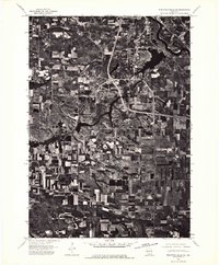
1975 Map of Wisconsin Dells SE
USGS Topo · Published 1976About this map
Wisconsin Dells and the surrounding Sauk County landscape are captured in this mid-1970s orthophotoquad, which uses aerial photography to document the region's transition from rural farmland to a developing recreational hub. The winding course of the Wisconsin River dominates the upper portion of the sheet, feeding into the distinctive, branching shoreline of Lake Delton. The imagery provides a clear view of the complex interstate interchanges and road networks that were becoming increasingly central to the area's growth during this era. Unlike traditional topographic maps, this photographic survey reveals the precise patterns of woodlots, agricultural fields, and emerging residential clearings, offering researchers an unfiltered look at the physical environment before further modern development altered the shoreline and timber patterns.
Find a feature on this map
3 named features on this map. Tap any name to fly to it.
Don’t see what you’re looking for? This feature index may not catch every label — zoom into the map to look around manually.
Map Details
Editions of this 1975 Wisconsin Dells SE Map
3 editions found

Other maps of this area

1895 · Baraboo
USGS Topo · 1:62,500

1901 · Denzer
USGS Topo · 1:62,500

1901 · The Dells
USGS Topo · 1:62,500

1902 · Briggsville
USGS Topo · 1:62,500

1908 · Baraboo
USGS Topo · 1:62,500

1957 · Wisconsin Dells
USGS Topo · 1:62,500

1957 · Madison
USGS Topo · 1:250,000

1958 · Briggsville
USGS Topo · 1:62,500

1958 · North Freedom
USGS Topo · 1:62,500

1959 · Baraboo
USGS Topo · 1:62,500