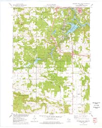
1975 Map of Wisconsin Dells South
USGS Topo · Published 1978About this map
Wisconsin River waters flow past the northern resort communities of Wisconsin Dells and Lake Delton in this mid-1970s survey. The landscape is a transition between the recreation-focused north, featuring Mirror Lake State Park and Lake Blass, and the agricultural south where Hogsback Ridge and the North Range define the horizon. Transportation infrastructure is prominent, with the Chicago Milwaukee St Paul and Pacific railroad line and the Baraboo-Dells Airport supporting the region's connectivity. Local history is anchored by rural landmarks such as Butterfield Cem and Webster Prairie Cem, while the conservation efforts of the Dell Creek State Wildlife Area protect the marshes of Dell Creek. Prominent geological features like Rattlesnake Knob and Coon Bluff rise above the surrounding valleys, marking the distinct topography of Dellona and Excelsior townships.
Find a feature on this map
53 named features on this map. Tap any name to fly to it.
Don’t see what you’re looking for? This feature index may not catch every label — zoom into the map to look around manually.
Map Details
Editions of this 1975 Wisconsin Dells South Map
3 editions found

Other maps of this area

1895 · Baraboo
USGS Topo · 1:62,500

1901 · Denzer
USGS Topo · 1:62,500

1901 · The Dells
USGS Topo · 1:62,500

1902 · Briggsville
USGS Topo · 1:62,500

1908 · Baraboo
USGS Topo · 1:62,500

1957 · Wisconsin Dells
USGS Topo · 1:62,500

1957 · Madison
USGS Topo · 1:250,000

1958 · Briggsville
USGS Topo · 1:62,500

1958 · North Freedom
USGS Topo · 1:62,500

1959 · Baraboo
USGS Topo · 1:62,500