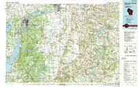
1985 Map of Wisconsin Rapids
USGS Topo · Published 1989About this map
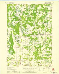
Wisconsin Rapids and the industrial corridor of the Wisconsin River dominate this mid-1980s landscape, illustrating a region defined by paper milling and water management. The river’s path is heavily altered by dams and reservoirs, visible in the wide expanses of Biron Flowage and the northern reaches of Petenwell Lake. Between the primary settlements of Port Edwards and Nekoosa, the map reveals a sophisticated network of transportation and land use, from the Soo Line rail corridors to the extensive drainage system of the Buena Vista marshlands, marked by numerous numbered features like Ditch No 1. Conservation and military footprints are significant, with the National Guard Bombing and Gunnery Range occupying the western flats while the Leola Marsh State Wildlife Area preserves the central wetlands. Small rural centers like Plainfield, Hancock, and Wild Rose anchor the eastern agricultural plains, providing a detailed look at Central Wisconsin's transition from river-industry hubs to upland farming.
Find a feature on this map
143 named features on this map. Tap any name to fly to it.
Don’t see what you’re looking for? This feature index may not catch every label — zoom into the map to look around manually.
Map Details
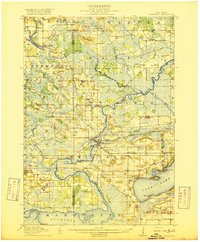
Editions of this 1985 Wisconsin Rapids Map
2 editions found

Other maps of this area

1915 · Neshkoro
USGS Topo · 1:48,000

1916 · Ripon
USGS Topo · 1:48,000
1918 · Neshkoro
USGS Topo · 1:62,500

1918 · Ripon
USGS Topo · 1:62,500

1921 · Mauston
USGS Topo · 1:62,500

1953 · Eau Claire
USGS Topo · 1:250,000
1954 · Marshfield
USGS Topo · 1:62,500
1955 · Clintonville
USGS Topo · 1:48,000

1955 · Tigerton
USGS Topo · 1:48,000
1955 · Rosholt
USGS Topo · 1:48,000