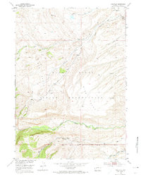
1952 Map of Wise Flat
USGS Topo · Published 1974About this map
The Wind River Indian Reservation in Fremont County is defined by its complex hydrology and high-altitude drainage systems. This 1952 field-checked survey reveals a landscape where the Wind River Base Line and an early Telephone Line slice across the high plains, providing essential survey and communication infrastructure. The northern portion is dominated by the Sage Creek system, including the Middle Fork and South Fork, which carve through the terrain near the prominent Norkok Butte. To the south, the terrain descends toward the North Fork Little Wind River, a major watercourse joined by smaller tributaries like Timmoco Creek. The expansive Wise Flat terrace sits above these river valleys, accessed by the St Lawrence Ranger Station Road, reflecting the area's mid-century management and the vital role of these waterways in the regional geography.
Find a feature on this map
17 named features on this map. Tap any name to fly to it.
Don’t see what you’re looking for? This feature index may not catch every label — zoom into the map to look around manually.
Map Details
Editions of this 1952 Wise Flat Map
3 editions found
Other maps of this area

1937 · Moccasin Lake
USGS Topo · 1:48,000

1943 · Moccasin Lake
USGS Topo · 1:62,500

1951 · Fort Washakie
USGS Topo · 1:24,000

1951 · Bull Lake East
USGS Topo · 1:24,000

1951 · Argo Butte
USGS Topo · 1:24,000

1952 · Wise Flat
USGS Topo · 1:24,000

1952 · Wind River
USGS Topo · 1:24,000

1952 · Bull Lake West
USGS Topo · 1:24,000

1952 · St. Lawrence Basin
USGS Topo · 1:24,000

1955 · Thermopolis
USGS Topo · 1:250,000