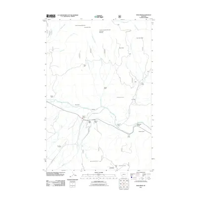
2011 Map of Wise River
USGS Topo · Published 2011About this map
The Big Hole River and its confluence with the Wise River form the focal point of this southwestern Montana landscape, where river-bottom settlements meet the mineral-rich slopes of the surrounding gulches. In this 2011 survey, the community of Wise River serves as a local hub, featuring the Wise River Post Office and Wise River Vol Fire Company. The terrain is marked by a legacy of resource extraction, with numerous workings such as the Deer Canyon Mine, Keystone Number 20 Mine, and the Triangle Gulch Mine scattered across the high ground of Bean Ridge and Burnt Dam Ridge. Transportation is defined by the Wise River Polaris Rd and a corridor noted as Railway Row Rd, reflecting the area's historic reliance on rail and road for mining and timber. Recreational and utility infrastructure is evident at the Jerry Creek Fishing Access and the two local airstrips, Wise River Airport and Jerry Creek Airport.
Find a feature on this map
49 named features on this map. Tap any name to fly to it.
Don’t see what you’re looking for? This feature index may not catch every label — zoom into the map to look around manually.
Map Details
Editions of this 2011 Wise River Map
This is the sole edition of this map. No revisions or reprints were ever made.
Other maps of this area

1893 · Dillon
USGS Topo · 1:250,000

1955 · Dillon
USGS Topo · 1:250,000

1957 · Dillon
USGS Topo · 1:250,000

1958 · Dillon
USGS Topo · 1:250,000

1958 · Vipond Park
USGS Topo · 1:62,500
1961 · Burnt Mountain
USGS Topo · 1:24,000
1961 · Dickie Peak
USGS Topo · 1:24,000

1961 · Dewey
USGS Topo · 1:24,000

1961 · Wise River
USGS Topo · 1:24,000

1962 · Dillon
USGS Topo · 1:250,000