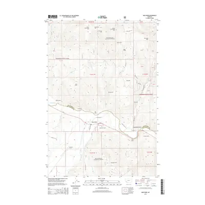
2014 Map of Wise River
USGS Topo · Published 2014About this map
Wise River sits at the confluence of its namesake waterway and the Big Hole River, serving as a central point in this mountain landscape near the Silver Bow and Beaverhead County line. The valley floor is marked by transportation history, featuring the Railway Row Rd and Narrow Guage Rd, which hint at the former industrial corridors that once moved timber or ore through these high corridors. To the north, the terrain rises sharply into the Beaverhead National Forest, culminating in peaks like Little Granulated Mtn and Grassy Granulated Mtn. The small settlement of Patterson Corner and the Wise River Airport provide evidence of modern infrastructure nestled within a complex system of gulches, including Keystone Gulch and Titan Gulch.
Find a feature on this map
61 named features on this map. Tap any name to fly to it.
Don’t see what you’re looking for? This feature index may not catch every label — zoom into the map to look around manually.
Map Details
Editions of this 2014 Wise River Map
This is the sole edition of this map. No revisions or reprints were ever made.
Other maps of this area

1893 · Dillon
USGS Topo · 1:250,000

1955 · Dillon
USGS Topo · 1:250,000

1957 · Dillon
USGS Topo · 1:250,000

1958 · Dillon
USGS Topo · 1:250,000

1958 · Vipond Park
USGS Topo · 1:62,500
1961 · Burnt Mountain
USGS Topo · 1:24,000
1961 · Dickie Peak
USGS Topo · 1:24,000

1961 · Dewey
USGS Topo · 1:24,000

1961 · Wise River
USGS Topo · 1:24,000

1962 · Dillon
USGS Topo · 1:250,000