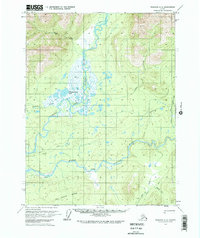
1970 Map of Wiseman A-2
USGS Topo · Published 1973About this map
The Koyukuk River and its major tributaries dominate this 1970 landscape, illustrating the intricate hydrology of the Yukon-Koyukuk region before significant modern development. The confluence of the North Fork Koyukuk River and the Middle Fork Koyukuk River creates an expansive network of wetlands and seasonal floodplains, including Florence Creek Lake. This interior wilderness is characterized by significant topographical relief, rising from the river valleys to the high peaks of the White Range in the south. Human activity is sparse, marked primarily by isolated cabins and a network of overland routes like the Winter Trail, which provided essential transit when the ground was frozen. Notable geographic markers such as a Pingo near John R Creek indicate the permafrost-driven geomorphology of the area, while family-named drainages like Smally Creek and Winnie Creek suggest a history of localized prospecting or seasonal habitation.
Find a feature on this map
15 named features on this map. Tap any name to fly to it.
Don’t see what you’re looking for? This feature index may not catch every label — zoom into the map to look around manually.
Map Details
Editions of this 1970 Wiseman A-2 Map
2 editions found
Other maps of this area

1951 · Bettles
USGS Topo · 1:250,000

1951 · Wiseman
USGS Topo · 1:250,000

1956 · Bettles
USGS Topo · 1:250,000

1956 · Wiseman
USGS Topo · 1:250,000

1964 · Wiseman
USGS Topo · 1:250,000

1970 · Wiseman A-1
USGS Topo · 1:63,360
1970 · Bettles D-1
USGS Topo · 1:63,360

1970 · Wiseman A-3
USGS Topo · 1:63,360

1970 · Wiseman A-2
USGS Topo · 1:63,360

1970 · Bettles D-3
USGS Topo · 1:63,360