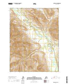
2017 Map of Wiseman B-2 NW
USGS Topo · Published 2017About this map
Gates of the Arctic National Park encompasses a significant portion of this interior Alaskan landscape, where the North Fork Koyukuk River meanders through a broad valley. The river's path is defined by numerous tight oxbows and marshy lowlands, characteristic of the subarctic drainage systems in the Yukon-Koyukuk region. Several significant tributaries descend from the surrounding high ground, including Bonanza Cr to the north and Ipnek Cr, which winds through the southern reaches. The map reveals a land defined almost entirely by its hydrography and topography, with no roads or settlements interrupting the wilderness. Smaller drainages like Richmond Cr highlight the intricate network of seasonal and perennial streams that feed into the larger Koyukuk watershed, reflecting the pristine state of this protected northern ecosystem.
Find a feature on this map
9 named features on this map. Tap any name to fly to it.
Don’t see what you’re looking for? This feature index may not catch every label — zoom into the map to look around manually.
Map Details
Editions of this 2017 Wiseman B-2 NW Map
This is the sole edition of this map. No revisions or reprints were ever made.
Other maps of this area

1951 · Wiseman
USGS Topo · 1:250,000

1956 · Wiseman
USGS Topo · 1:250,000

1964 · Wiseman
USGS Topo · 1:250,000

1971 · Wiseman C-2
USGS Topo · 1:63,360
1971 · Wiseman B-3
USGS Topo · 1:63,360
1971 · Wiseman B-2
USGS Topo · 1:63,360
1971 · Wiseman C-3
USGS Topo · 1:63,360
2016 · Wiseman C-3 SE
USGS Topo · 1:25,000
2016 · Wiseman B-3 SE
USGS Topo · 1:25,000
2016 · Wiseman B-3 NE
USGS Topo · 1:25,000