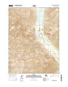
2016 Map of Wiseman B-4 NE
USGS Topo · Published 2016About this map
Wild Lake dominates the northern landscape of this Brooks Range interior, marking a significant hydrologic feature where the terrain begins its steep ascent into the surrounding peaks. The drainage pattern is defined by the Wild River, which flows south from the lake through a glaciated valley. This 2016 survey illustrates the remote character of the Yukon-Koyukuk region, where the land is primarily shaped by watercourses like Seward Cr and Lake Cr rather than human infrastructure. Small tributaries such as McCamant Cr and Crevice Cr feed into the primary river system, tracing narrow paths through the high-elevation contours. The map effectively captures a wilderness area defined by its verticality and the pristine state of its watershed, offering a precise record of the natural topography in this part of northern Alaska.
Find a feature on this map
10 named features on this map. Tap any name to fly to it.
Don’t see what you’re looking for? This feature index may not catch every label — zoom into the map to look around manually.
Map Details
Editions of this 2016 Wiseman B-4 NE Map
This is the sole edition of this map. No revisions or reprints were ever made.
Other maps of this area

1951 · Wiseman
USGS Topo · 1:250,000

1956 · Wiseman
USGS Topo · 1:250,000

1964 · Wiseman
USGS Topo · 1:250,000

1971 · Wiseman C-4
USGS Topo · 1:63,360
1971 · Wiseman B-3
USGS Topo · 1:63,360
1971 · Wiseman C-3
USGS Topo · 1:63,360
1971 · Wiseman B-4
USGS Topo · 1:63,360
2016 · Wiseman B-4 SE
USGS Topo · 1:25,000
2016 · Wiseman B-4 SW
USGS Topo · 1:25,000
2016 · Wiseman C-4 SW
USGS Topo · 1:25,000