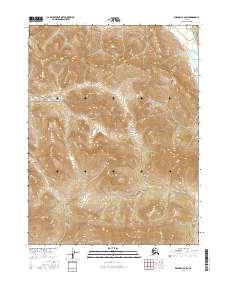
2016 Map of Wiseman B-6 SW
USGS Topo · Published 2016About this map
Gates of the Arctic National Park encompasses the majority of this high-latitude terrain, preserving a vast expanse of the central Brooks Range in the Alaskan interior. The landscape is defined by its dramatic relief and alpine drainage systems, with the waters of Mettenpherg Cr flowing southward in the eastern portion of the quadrangle. In the north, Pass Cr cuts through the high elevations, while Cummings Cr marks the southwestern topography. This 2016 survey documents the untouched character of the wilderness within the Yukon-Koyukuk region, reflecting the strict conservation status of the park. The map illustrates the complex township and range boundaries, including t29n r24w and t28n r24w, which overlay this roadless and undeveloped environment.
Find a feature on this map
8 named features on this map. Tap any name to fly to it.
Don’t see what you’re looking for? This feature index may not catch every label — zoom into the map to look around manually.
Map Details
Editions of this 2016 Wiseman B-6 SW Map
This is the sole edition of this map. No revisions or reprints were ever made.
Other maps of this area

1951 · Survey Pass
USGS Topo · 1:250,000

1951 · Wiseman
USGS Topo · 1:250,000

1956 · Wiseman
USGS Topo · 1:250,000

1956 · Survey Pass
USGS Topo · 1:250,000

1964 · Survey Pass
USGS Topo · 1:250,000

1964 · Wiseman
USGS Topo · 1:250,000

1966 · Survey Pass
USGS Topo · 1:250,000
1970 · Wiseman A-6
USGS Topo · 1:63,360
1986 · Survey Pass A-1
USGS Topo · 1:63,360
1986 · Wiseman B-6
USGS Topo · 1:63,360