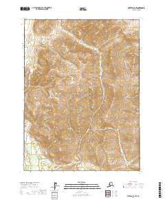
2017 Map of Wiseman C-2 SW
USGS Topo · Published 2017About this map
Gates Of The Arctic National Park encompasses the majority of this interior Alaskan wilderness, where the high ridges of the Brooks Range drop toward the valley floor. The southwestern corner of the sheet is defined by the North Fork Koyukuk River, a primary drainage system for the region. Several significant tributaries carve through the steep terrain, including Jumbo Cr in the north and the centrally located Bonanza Cr. The map captures a landscape largely untouched by modern road infrastructure, defined instead by its drainage patterns and the massive protected land block of the national park. The presence of Conglomerate Cr along the eastern boundary further illustrates the complex watershed that feeds the larger Koyukuk system in this remote census area.
Find a feature on this map
9 named features on this map. Tap any name to fly to it.
Don’t see what you’re looking for? This feature index may not catch every label — zoom into the map to look around manually.
Map Details
Editions of this 2017 Wiseman C-2 SW Map
This is the sole edition of this map. No revisions or reprints were ever made.
Other maps of this area

1951 · Wiseman
USGS Topo · 1:250,000

1956 · Wiseman
USGS Topo · 1:250,000

1964 · Wiseman
USGS Topo · 1:250,000

1971 · Wiseman C-2
USGS Topo · 1:63,360
1971 · Wiseman B-3
USGS Topo · 1:63,360
1971 · Wiseman B-2
USGS Topo · 1:63,360
1971 · Wiseman C-3
USGS Topo · 1:63,360
2016 · Wiseman C-3 SE
USGS Topo · 1:25,000
2016 · Wiseman C-3 NE
USGS Topo · 1:25,000
2016 · Wiseman B-3 NE
USGS Topo · 1:25,000