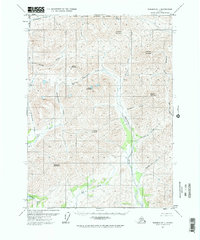
1971 Map of Wiseman D-1
USGS Topo · Published 1974About this map
Kinnorutin Pass serves as a critical high-altitude corridor in this northern landscape, which remains entirely devoid of established roads or trails during the early 1970s. The drainage patterns are defined by the southward flow of the N Fk Koyukuk River and the Hammond River, which carve through a series of prominent peaks. Massive geological features like Alhamblar Mountain, Falsoola Mountain, and Whiteface Mountain dictate the terrain, with numerous alpine tributaries such as Trembley Creek and St Patricks Creek feeding the larger river systems. This map shows the area as it existed just before major industrial changes in the region, capturing an environment where survey lines were predetermined by the Bureau of Land Management but had not yet been physically marked on the ground.
Find a feature on this map
25 named features on this map. Tap any name to fly to it.
Don’t see what you’re looking for? This feature index may not catch every label — zoom into the map to look around manually.
Map Details
Editions of this 1971 Wiseman D-1 Map
2 editions found
Other maps of this area

1951 · Chandler Lake
USGS Topo · 1:250,000

1951 · Chandalar
USGS Topo · 1:250,000

1951 · Brooks
USGS Topo · 1:250,000

1951 · Wiseman
USGS Topo · 1:250,000

1956 · Chandalar
USGS Topo · 1:250,000

1956 · Wiseman
USGS Topo · 1:250,000

1956 · Philip Smith Mountains
USGS Topo · 1:250,000

1956 · Chandler Lake
USGS Topo · 1:250,000

1964 · Wiseman
USGS Topo · 1:250,000

1964 · Chandalar
USGS Topo · 1:250,000