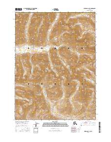
2016 Map of Wiseman D-3 NE
USGS Topo · Published 2016About this map
Gates Of The Arctic National Park encompasses this entire northern landscape within the Yukon-Koyukuk Census Area, centered on the prominent peak of Gray Mtn. The terrain is defined by a network of drainage systems, most notably the south-flowing Tinayguk River and its varied feeder streams. The map reveals a wild, unpopulated environment where natural landforms dictate the passage through the Brooks Range. These watersheds, including Shushuluk Creek to the east and Wolf Creek to the west, provide essential orientation in a region without developed roads or settlements. The survey captures the pure topography of the Alaskan interior, showing how the headwaters of Fish Creek and Tributary Creek carve through the high-elevation ridges of the central arctic wilderness.
Find a feature on this map
14 named features on this map. Tap any name to fly to it.
Don’t see what you’re looking for? This feature index may not catch every label — zoom into the map to look around manually.
Map Details
Editions of this 2016 Wiseman D-3 NE Map
This is the sole edition of this map. No revisions or reprints were ever made.
Other maps of this area

1951 · Chandler Lake
USGS Topo · 1:250,000

1951 · Wiseman
USGS Topo · 1:250,000

1956 · Wiseman
USGS Topo · 1:250,000

1956 · Chandler Lake
USGS Topo · 1:250,000

1964 · Wiseman
USGS Topo · 1:250,000

1964 · Chandler Lake
USGS Topo · 1:250,000
1971 · Chandler Lake A-2
USGS Topo · 1:63,360

1971 · Chandler Lake A-3
USGS Topo · 1:63,360
1971 · Wiseman D-2
USGS Topo · 1:63,360
1971 · Wiseman D-3
USGS Topo · 1:63,360