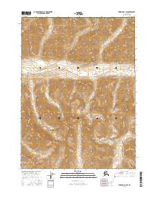
2016 Map of Wiseman D-3 NW
USGS Topo · Published 2016About this map
Gates of the Arctic National Park dominates this northern landscape, which preserves a portion of the central Brooks Range in the mid-2010s. The terrain is defined by the high peaks of the Endicott Mountains, with elevations reaching well above 5,000 feet. Drainage patterns are established by the Tinayguk River, which flows through the western half of the quadrangle, and Wolf Cr in the southeast. This survey, conducted within the Yukon-Koyukuk Census Area, shows a roadless wilderness area where the Public Land Survey System grid lines of t36n r17w and surrounding townships mark the only formal human overlay on a territory primarily shaped by alpine geography and glacial carved valleys.
Find a feature on this map
11 named features on this map. Tap any name to fly to it.
Don’t see what you’re looking for? This feature index may not catch every label — zoom into the map to look around manually.
Map Details
Editions of this 2016 Wiseman D-3 NW Map
This is the sole edition of this map. No revisions or reprints were ever made.
Other maps of this area

1951 · Chandler Lake
USGS Topo · 1:250,000

1951 · Wiseman
USGS Topo · 1:250,000

1956 · Wiseman
USGS Topo · 1:250,000

1956 · Chandler Lake
USGS Topo · 1:250,000

1964 · Wiseman
USGS Topo · 1:250,000

1964 · Chandler Lake
USGS Topo · 1:250,000

1971 · Chandler Lake A-3
USGS Topo · 1:63,360
1971 · Wiseman D-4
USGS Topo · 1:63,360
1971 · Wiseman D-3
USGS Topo · 1:63,360
2016 · Wiseman D-3 SE
USGS Topo · 1:25,000