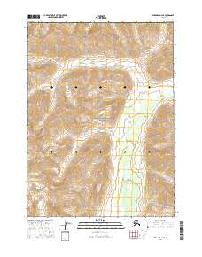
2016 Map of Wiseman D-4 NE
USGS Topo · Published 2016About this map
Gates of the Arctic National Park encompasses the heart of this landscape within the Yukon-Koyukuk Census Area, revealing the complex drainage systems of Alaska's northern interior. The Tinayguk River flows southward through the eastern half of the map, carving a path through the high-elevation terrain. In the northwestern corner, Savioyok Cr winds through the hills, while Publituk Cr emerges in the southwest. The 2016 survey documents the untouched character of these headwaters, where the absence of roads or settlements highlights the isolation of this protected wilderness. The topographic data provides a detailed look at the watercourses and steep contour gradients that define this portion of the Brooks Range.
Find a feature on this map
13 named features on this map. Tap any name to fly to it.
Don’t see what you’re looking for? This feature index may not catch every label — zoom into the map to look around manually.
Map Details
Editions of this 2016 Wiseman D-4 NE Map
This is the sole edition of this map. No revisions or reprints were ever made.
Other maps of this area

1951 · Chandler Lake
USGS Topo · 1:250,000

1951 · Wiseman
USGS Topo · 1:250,000

1956 · Wiseman
USGS Topo · 1:250,000

1956 · Chandler Lake
USGS Topo · 1:250,000

1964 · Wiseman
USGS Topo · 1:250,000

1964 · Chandler Lake
USGS Topo · 1:250,000

1971 · Chandler Lake A-3
USGS Topo · 1:63,360
1971 · Wiseman D-4
USGS Topo · 1:63,360
1971 · Wiseman D-3
USGS Topo · 1:63,360
2016 · Wiseman D-4 SW
USGS Topo · 1:25,000