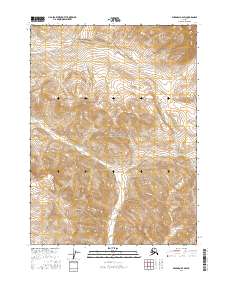
2016 Map of Wiseman D-4 SW
USGS Topo · Published 2016About this map
Gates of the Arctic National Park encompasses the majority of this landscape, representing a remote reach of the Brooks Range during the mid-2010s. The terrain is defined by the high-elevation drainage systems of the Allen River and Publituk Cr, which carve through steep topographical contours. The map reflects a wilderness area largely devoid of permanent human infrastructure, highlighting the preservation of natural waterways and undeveloped federal lands in the Yukon-Koyukuk region. Researchers interested in the hydrology of northern Alaska can trace the winding course of Publituk Cr as it flows toward the eastern margin of the quadrangle, while the Allen River dominates the central and southern valleys.
Find a feature on this map
7 named features on this map. Tap any name to fly to it.
Don’t see what you’re looking for? This feature index may not catch every label — zoom into the map to look around manually.
Map Details
Editions of this 2016 Wiseman D-4 SW Map
This is the sole edition of this map. No revisions or reprints were ever made.
Other maps of this area

1951 · Wiseman
USGS Topo · 1:250,000

1956 · Wiseman
USGS Topo · 1:250,000

1964 · Wiseman
USGS Topo · 1:250,000

1971 · Wiseman C-4
USGS Topo · 1:63,360
1971 · Wiseman D-4
USGS Topo · 1:63,360

1971 · Wiseman C-5
USGS Topo · 1:63,360
1971 · Wiseman D-5
USGS Topo · 1:63,360
2016 · Wiseman C-5 NE
USGS Topo · 1:25,000
2016 · Wiseman C-4 NE
USGS Topo · 1:25,000
2016 · Wiseman D-5 SE
USGS Topo · 1:25,000