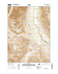
2016 Map of Wiseman D-4 SE
USGS Topo · Published 2016About this map
Gates of the Arctic National Park dominates this northern landscape, representing a vast area of protected wilderness as it was documented in 2016. The terrain is defined by the winding course of the Tinayguk River, which flows southward through the central portion of the quadrangle. This hydrographic network is supported by smaller tributaries including Publikuk Cr in the northwest and Swamp Cr in the south. The map provides a detailed view of the Public Land Survey System grid, showing the intersections of townships t35n r18w and t34n r18w. Without roads or established settlements, the focus remains entirely on the natural drainage patterns and the preservation of the Brooks Range environment within the park boundaries.
Find a feature on this map
10 named features on this map. Tap any name to fly to it.
Don’t see what you’re looking for? This feature index may not catch every label — zoom into the map to look around manually.
Map Details
Editions of this 2016 Wiseman D-4 SE Map
This is the sole edition of this map. No revisions or reprints were ever made.
Other maps of this area

1951 · Wiseman
USGS Topo · 1:250,000

1956 · Wiseman
USGS Topo · 1:250,000

1964 · Wiseman
USGS Topo · 1:250,000

1971 · Wiseman C-4
USGS Topo · 1:63,360
1971 · Wiseman D-4
USGS Topo · 1:63,360
1971 · Wiseman D-3
USGS Topo · 1:63,360
1971 · Wiseman C-3
USGS Topo · 1:63,360
2016 · Wiseman C-4 NE
USGS Topo · 1:25,000
2016 · Wiseman C-3 NW
USGS Topo · 1:25,000
2016 · Wiseman D-4 SW
USGS Topo · 1:25,000