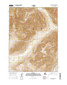
2016 Map of Wiseman D-5 NW
USGS Topo · Published 2016About this map
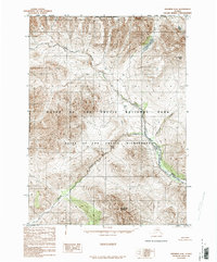
Gates of the Arctic National Park encompasses this entire portion of the Brooks Range, dominated by the high elevations of the Endicott Mountains. This remote wilderness in the Yukon-Koyukuk Census Area is defined by its complex drainage network, where multiple creeks descend from steep ridges into larger glacial valleys. The northern portion of the sheet is marked by the headwaters of Yenituk Cr and Loon Cr, while the southwestern quadrant follows the serpentine course of Walkaround Cr. In the southeast, the terrain drops toward the John River valley, where it is joined by Publituk Cr. The absence of roads or established trails highlights the preserved state of this subarctic environment, where the topographic contours reveal a landscape shaped by ice and water rather than human industry.
Find a feature on this map
15 named features on this map. Tap any name to fly to it.
Don’t see what you’re looking for? This feature index may not catch every label — zoom into the map to look around manually.
Map Details
Editions of this 2016 Wiseman D-5 NW Map
This is the sole edition of this map. No revisions or reprints were ever made.
Other maps of this area

1951 · Chandler Lake
USGS Topo · 1:250,000

1951 · Wiseman
USGS Topo · 1:250,000

1956 · Wiseman
USGS Topo · 1:250,000

1956 · Chandler Lake
USGS Topo · 1:250,000

1964 · Wiseman
USGS Topo · 1:250,000

1964 · Chandler Lake
USGS Topo · 1:250,000
1971 · Wiseman D-5
USGS Topo · 1:63,360
1986 · Chandler Lake A-5
USGS Topo · 1:63,360
1986 · Chandler Lake A-4
USGS Topo · 1:63,360
1986 · Wiseman D-6
USGS Topo · 1:63,360