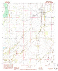
1983 Map of Wisner
USGS Topo · Published 1984About this map
Wisner anchors this agricultural landscape of the Louisiana delta, where the Missouri Pacific railroad cuts a straight north-south line through the alluvial plain. The map documents a dense network of small communities and rural religious life, evidenced by a high concentration of churches including New Alpha & Omega Ch, New Light Ch, and Mt Pleasant Ch. A distinct boundary between Franklin Parish and Catahoula Parish is defined by the winding course of Deer Creek, which meanders through the eastern section of the quadrangle.
Find a feature on this map
31 named features on this map. Tap any name to fly to it.
Don’t see what you’re looking for? This feature index may not catch every label — zoom into the map to look around manually.
Map Details
Editions of this 1983 Wisner Map
This is the sole edition of this map. No revisions or reprints were ever made.
Other maps of this area

1935 · Winnsboro
USGS Topo · 1:62,500

1939 · Fort Necessity
USGS Topo · 1:62,500

1941 · Sicily Island
USGS Topo · 1:62,500

1941 · Harrisonburg
USGS Topo · 1:62,500

1953 · Natchez
USGS Topo · 1:250,000

1955 · Jackson
USGS Topo · 1:250,000

1956 · Natchez
USGS Topo · 1:250,000

1957 · Sicily Island
USGS Topo · 1:62,500

1958 · Winnsboro
USGS Topo · 1:62,500

1958 · Fort Necessity
USGS Topo · 1:62,500