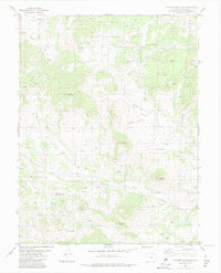
1983 Map of Witcher Mountain
USGS Topo · Published 1983About this map
Pike National Forest encompasses the high country of Park County in this early 1980s topographic study, where the terrain is defined by prominent peaks including Saddle Mountain, Castle Mountain, and the namesake Witcher Mountain. The landscape is a network of drainage basins, with Wagon Tongue Creek and Fish Creek carving through the northern sections while Fourmile Creek dominates the central valley. A notable concentration of mining activity is evident through numerous prospects scattered across the slopes of Mc Intyre Mountain and Doe Ridge, indicating the persistent mineral interest in this portion of the Colorado Rockies. Transportation and access are limited to a handful of routes such as Thirtynine Mile Road, alongside specialized features like a rural Landing Strip and an aqueduct system, reflecting the area's transition between resource extraction and managed forest land.
Find a feature on this map
35 named features on this map. Tap any name to fly to it.
Don’t see what you’re looking for? This feature index may not catch every label — zoom into the map to look around manually.
Map Details
Editions of this 1983 Witcher Mountain Map
2 editions found
Other maps of this area

1894 · Pikes Peak
USGS Topo · 1:125,000

1901 · Pikes Peak
USGS Topo · 1:125,000

1942 · Cover Mtn.
USGS Topo · 1:62,500

1948 · Cover Mtn.
USGS Topo · 1:62,500

1954 · Pueblo
USGS Topo · 1:250,000

1956 · Lake George
USGS Topo · 1:24,000

1956 · Elevenmile Canyon
USGS Topo · 1:24,000

1956 · Spinney Mountain
USGS Topo · 1:24,000

1957 · Pueblo
USGS Topo · 1:250,000

1958 · Pueblo
USGS Topo · 1:250,000