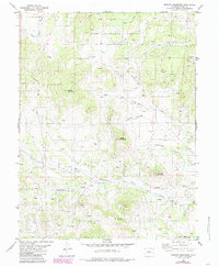
1983 Map of Witcher Mountain
USGS Topo · Published 1985About this map
Bumgarner stands as a focal point in this high-altitude landscape within the Pike National Forest, captured during the early 1980s. The area is defined by significant topographic rises, including Witcher Mountain, Mc Intyre Mountain, and Saddle Mountain. Water sources are abundant across the terrain, with drainage provided by Fourmile Creek, Wagon Tongue Creek, and Cottonwood Creek, alongside numerous smaller springs and gulches like Brooker Gulch and Castle Gulch.
Find a feature on this map
24 named features on this map. Tap any name to fly to it.
Don’t see what you’re looking for? This feature index may not catch every label — zoom into the map to look around manually.
Map Details
Editions of this 1983 Witcher Mountain Map
2 editions found
Other maps of this area

1894 · Pikes Peak
USGS Topo · 1:125,000

1901 · Pikes Peak
USGS Topo · 1:125,000

1942 · Cover Mtn.
USGS Topo · 1:62,500

1948 · Cover Mtn.
USGS Topo · 1:62,500

1954 · Pueblo
USGS Topo · 1:250,000

1956 · Lake George
USGS Topo · 1:24,000

1956 · Elevenmile Canyon
USGS Topo · 1:24,000

1956 · Spinney Mountain
USGS Topo · 1:24,000

1957 · Pueblo
USGS Topo · 1:250,000

1958 · Pueblo
USGS Topo · 1:250,000