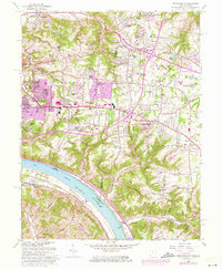
1961 Map of Withamsville
USGS Topo · Published 1975About this map
The suburban expansion of eastern Cincinnati is documented in this 1961 survey, showing the residential transformation of southern Union and Anderson townships. New residential developments like Sherwood Village, Paddison Hills, and Mount Carmel Heights spread across the uplands, while the Ohio River remains the primary geographic anchor to the south. Along the river, the Chesapeake and Ohio railroad corridor tracks the shoreline past the State Fish Hatchery. Significant religious and educational institutions, including St Gregory Seminary and Sacred Heart Seminary, highlight the area's cultural infrastructure during this mid-century growth period. The map also captures the earlier rural character persisting through named valleys like Nine Mile Creek and Tenmile Creek, alongside local landmarks like Mt Moriah Church and the Coldstream Country Club.
Find a feature on this map
73 named features on this map. Tap any name to fly to it.
Don’t see what you’re looking for? This feature index may not catch every label — zoom into the map to look around manually.
Map Details
Editions of this 1961 Withamsville Map
3 editions found
Other maps of this area

1898 · East Cincinnati
USGS Topo · 1:62,500

1914 · East Cincinnati
USGS Topo · 1:62,500

1914 · Batavia
USGS Topo · 1:48,000

1916 · Batavia
USGS Topo · 1:62,500

1929 · Alexandria
USGS Topo · 1:48,000

1931 · Felicity
USGS Topo · 1:62,500

1936 · Alexandria
USGS Topo · 1:62,500

1952 · Newport
USGS Topo · 1:24,000

1953 · Laurel
USGS Topo · 1:24,000

1953 · Withamsville
USGS Topo · 1:24,000