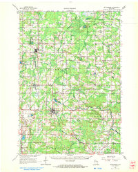
1964 Map of Wittenberg
USGS Topo · Published 1972About this map
The junction of the Chicago and North Western railway at Eland and Wittenberg anchors this mid-century portrait of the Shawano and Marathon county line. The landscape is defined by the winding course of the Middle Branch Embarrass River and the South Branch Embarrass River, supporting a series of small agricultural and timber-linked settlements. In the village of Wittenberg, the map records the Homme Home for Boys and Homme Pond, while nearby Birnamwood shows established civic features like St Philomene Cem and Forest Cem. The era's transportation shifts are visible in the numerous labeled sections of Old RR Gr and Old Grade, marking where earlier rail lines had already begun to fade into the Wisconsin countryside. Numerous rural institutions, including the Scandinavian Ch and Holy Family Cem, provide specific points of interest for genealogists tracing family ties to the Hutchins and Morris townships.
Find a feature on this map
70 named features on this map. Tap any name to fly to it.
Don’t see what you’re looking for? This feature index may not catch every label — zoom into the map to look around manually.
Map Details
Editions of this 1964 Wittenberg Map
2 editions found

Other maps of this area

1899 · Wausau
USGS Topo · 1:125,000

1902 · Wausau
USGS Topo · 1:125,000

1951 · Doering
USGS Topo · 1:48,000

1952 · Antigo
USGS Topo · 1:48,000

1952 · White Lake
USGS Topo · 1:48,000

1953 · Hatley
USGS Topo · 1:48,000

1954 · Wittenberg
USGS Topo · 1:48,000

1954 · Gresham
USGS Topo · 1:48,000

1954 · Iron Mountain
USGS Topo · 1:250,000

1955 · Clintonville
USGS Topo · 1:48,000