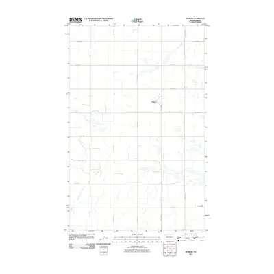
2011 Map of Woburn
USGS Topo · Published 2011About this map
Woburn stands as the primary namesake settlement in this northern Burke County landscape, situated within a high-plains region defined by a high density of small prairie potholes and ephemeral wetlands. The terrain is drained by the meandering East Branch Short Creek in the southwest and Stony Creek in the northeast, reflecting the natural hydrology of the Missouri Plateau before it meets the international border. A rigid section-line road grid, including County Rd-13 and 94th St NW, organizes the rural space, which remains sparsely populated outside of isolated farmsteads. For those researching local history or genealogy, Zion Cemetery in the southeastern quadrant serves as a significant landmark, marking the long-standing community ties in this agricultural corner of North Dakota.
Find a feature on this map
17 named features on this map. Tap any name to fly to it.
Don’t see what you’re looking for? This feature index may not catch every label — zoom into the map to look around manually.
Map Details
Editions of this 2011 Woburn Map
This is the sole edition of this map. No revisions or reprints were ever made.
Other maps of this area

1947 · Flaxton
USGS Topo · 1:24,000

1948 · Flaxton
USGS Topo · 1:24,000

1948 · Coteau
USGS Topo · 1:24,000

1948 · Woburn
USGS Topo · 1:24,000

1948 · Vanville NE
USGS Topo · 1:24,000

1949 · Rennie Lake
USGS Topo · 1:24,000

1949 · Portal
USGS Topo · 1:24,000
1949 · Northgate
USGS Topo · 1:24,000

1950 · Vanville NE
USGS Topo · 1:24,000

1950 · Flaxton
USGS Topo · 1:62,500